El Nino Beranjak Hilang dari Indonesia, Nasa Peringatkan Dampak Pemanasan Global
Nasa Say El Nino Should Start to Disappear - but Warn Global Warming Means `Anything Could Happen`
Editor : Ismail Gani
Translator : Novita Cahyadi
MELINTASI Pasifik, Indonesia dan negara-negara lainnya dilanda kekeringan.
"Hal ini pernah terjadi ´dalam satu abad´ seperti yang kita lalui pada 97-98.
Pertanyaannya adalah: akankah fenomena ini membawa California dan wilayah lain di kawasan barat akan dilanda kekeringan? Dan seberapa cepat kita akan dilanda La Nina?´
Bill Patzert, pakar iklim di Jet Propulsion Laboratory NASA, melihat potensi puncak kedua untuk El Nino.
Dia menunjuk pada sebuah relaksasi terbaru dalam pergerakan angin dan ledakan angin barat yang mampu mengisi ulang tren pemanasan di Pasifik timur.
Lemahnya pergerakan angin di Pasifik timur memungkinkan semburan angin barat untuk mendorong air hangat ke Amerika.
Patzert menduga Februari dan Maret 2016 masih merupakan periode sangat aktif El Nino yang mendorong perubahan cuaca di sepanjang pantai barat Amerika.
Badan pengamat cuaca sebelumnya mengungkapkan efek rekor bencana tahun ini akibat El Nino sebagai dampak perubahan cuaca di seluruh dunia.
Mereka mengatakan bahwa meskipun mereka mengharapkan anomali suhu permukaan laut di kawasan tropis Pasifik yang menurun secara bertahap selama beberapa bulan ke depan, ´masih banyak hal yang mungkin terjadi.´
Untuk Amerika, mereka memperingatkan efeknya ´baru saja dimulai´.
´El Nino mencatat beberapa perubahan cuaca yang mengesankan pada Desember, dan kami mendukung transisi ke kondisi netral oleh akhir musim semi atau awal musim panas," seperti dikatakan oleh Emily Becker dari NOAA yang dilansir MailOnline.
Indeks Nino 3.4, yang membandingkan suhu permukaan laut di Pasifik timur-tengah dengan rata-rata jangka panjang, memecahkan rekor pada Desember, rata-rata di atas 2,38° C, melebihi Desember 1997 pada 2,24 ° C.
´Musim utama untuk dampak El Nino di AS (Januari-Maret) baru saja dimulai di AS, tapi dampaknya mereda di daerah lain di dunia," kata Becker.
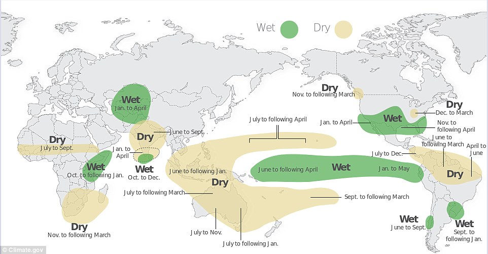
Dampak El Nino khas Australia adalah kondisi kering di sebagian besar benua sekitar Juli sampai Desember, tetapi selama periode ini belum ada dampak signifikan kecuali di bagian timur Australia.
Ada kemungkinan bahwa rekor hangat Samudra Hindia memiliki efek yang kuat pada iklim di Australia tahun ini, pengingat bahwa sistem iklim memiliki banyak bagian yang bergerak, dan dampak dari El Nino diharapkan, tetapi tidak dijamin.
Katakanlah, di daerah lain di dunia, dampak El Nino lebih jelas. Jauh lebih dari biasanya hujan turun di Afrika timur, seperti musim hujan ´hujan singkat´ mereka (Oktober-Desember) ditingkatkan dengan El Niño, sementara Afrika Selatan menghadapi kondisi kering lanjutan. Uruguay, Brazil selatan, dan Paraguay juga mengalami banyak hujan, dan Amerika Selatan di bagian utara telah kering, seperti yang sering terjadi pada September-Desember selama El Nino.
Pengamat cuaca mengharapkan anomali suhu permukaan laut di Pasifik tropis menurun secara bertahap selama beberapa bulan ke depan, dan diperkirakan transisi ke kondisi netral oleh akhir musim semi atau awal musim panas.
Meteorologi mengatakan saat El Nino telah menyerbu jalan ke buku rekor, pada 1997-1998 sebagai yang terkuat yang tercatat.
Mike Halpert, wakil direktur federal Pusat Prediksi Iklim, mengatakan angka awal untuk Oktober-November-Desember sesuai dengan periode waktu yang sama pada 1997 sebagai El Nino yang terkuat.
Badan Meteorologi mengukur El Nino berdasarkan bagian-bagian betapa hangatnya Pasifik tengah selama tiga bulan berturut-turut.
Catatan kembali ke 1950.
El Nino adalah pemanasan alami dari Pasifik tengah yang mengubah cuaca di seluruh dunia, termasuk membawa lebih banyak hujan ke California.
Halpert mengatakan apa yang sebenarnya penting adalah apa yang diakibatkan oleh El Nino selama Januari, sebaga masa puncak dari dampaknya.
Direktur cuaca meteorologi Jeff Masters mengatakan ´Dampak terkuat El Nino akhirnya mungkin terjadi di California,´ sebagai rangkaian dari puncak musim kering.
ACROSS the Pacific, Indonesia and other areas have been dry.
´It has been another ´event of the century´ much like the one we just had in 97–98.
The question is: will this event bring California and other western areas out of drought? And how quickly will we flip into La Nina?´
Bill Patzert, a climatologist at NASA´s Jet Propulsion Laboratory, sees the potential for a second peak for this El Niño.
He points to a recent relaxation in the trade winds and a west wind burst that could refuel the warming trend in the eastern Pacific.
Weaker trade winds in the eastern Pacific allow west wind bursts to push warm waters toward the Americas.
Patzert suspects February and March 2016 could still be very active months for El Nino-driven weather along the western coasts of the Americas.
Forecasters have previously revealed the catastrophic effects this year´s record breaking El Nino has had on weather around the world.
They say that even though they expect the sea surface temperature anomalies in the tropical Pacific to decrease gradually over the next several months, ´there is still a lot going on´.
For America, they warn the effect is ´just beginning´.
´El Nino put up some pretty impressive numbers in December, and we´re favouring a transition to neutral conditions by the late spring or early summer.´ Emily Becker of the NOAA said.
The Nino3.4 index, which compares ocean surface temperatures in the east-central Pacific to the long-term average, broke the record in December, coming in at 2.38°C above average, surpassing December 1997´s 2.24°C.
´The main season for El Niño impacts in the U.S. (January–March) is just beginning in the U.S., but it´s winding down in other areas of the world,´ Becker said.
Australia´s typical El Niño impact is dry conditions over most of the continent from about July through December, but through this period there hasn´t been a very clear deficit except in portions of eastern Australia.
It´s possible that a record warm Indian Ocean had a strong effect on the climate in Australia this year, a reminder that the climate system has a lot of moving parts, and impacts from El Niño are expected, but not guaranteed.
That said, in other areas of the world, El Niño impacts were clearer. Much more rain than normal fell in eastern Africa, as their ´short rains´ rainy season (October–December) was enhanced by El Niño, while southern Africa has had continued dry conditions. Uruguay, southern Brazil, and Paraguay also experienced a lot of rain, and northern South America has been dry, as often happens in September–December during El Niño.
Forecasters expect the sea surface temperature anomalies in the tropical Pacific to decrease gradually over the next several months, and we´re favouring a transition to neutral conditions by the late spring or early summer.
Meteorologists say the current El Nino has stormed its way into the record books, tying 1997-1998 as the strongest recorded.
Mike Halpert, deputy director of the federal Climate Prediction Center, said initial figures for October-November-December match the same time period in 1997 for the strongest El Nino.
Meteorologists measure El Nino based on how warm parts of the central Pacific for three consecutive months.
Records go back to 1950.
El Nino is the natural warming of the central Pacific that changes weather worldwide, including bringing more rain to California.
Halpert said what really matters is what El Nino does during January, when its impact peaks.
Weather Underground meteorology director Jeff Masters said ´Darth Nino may finally have California in its sights,´ as a series of storms may dent record drought.