Foto Satelit Ungkap Gunung Agung dan Batur di Bali Terhubung `Sistem Pipa` Bawah Tanah
Satellite Images Reveal Bali`s Two Volcanoes are Connected and Share the Same `Plumbing System`
Editor : Ismail Gani
Translator : Novita Cahyadi
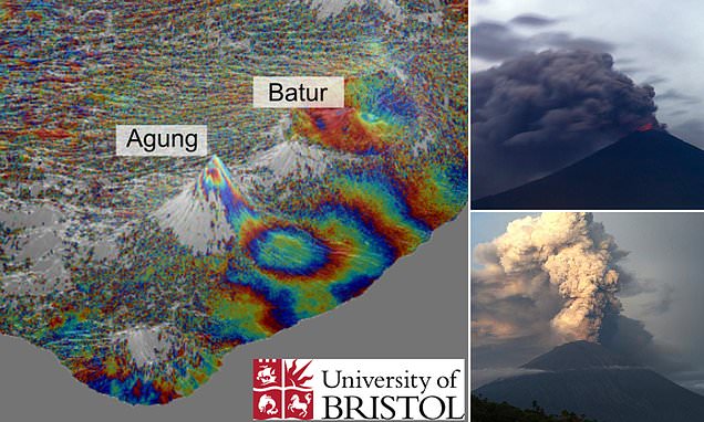
FOTO-FOTO satelit mengungkap adanya semacam sistem pipa dari gunung berapi Agung di Bali mungkin terhubung ke tetangganya, Gunung Batur, yang terpisah 18 km.
Para ilmuwan sedang mempelajari gunung berapi saat terbangun dari tidur 50 tahun dan memuntahkan abu erupsi ke atmosfer selama beberapa pekan pada akhir 2017.
Foto-foto dari Badan Antariksa Eropa mengungkapkan gelembung bawah tanah yang tidak biasa selebar 10 cm di sisi utara gunung berapi, lebih dari 5 km dari puncak gunung.
Fakta ini, diklaim para pakar, membuktikan magma gunung dapat bergerak secara horizontal maupun vertikal, yang menunjukkan secara fisik terkait dengan Gunung Batur.
Tim ilmuwan, yang dipimpin oleh Universitas Bristol, menggunakan teknologi satelit ESA untuk melihat fluktuasi level permukaan selama aktivitas gunung berapi pada 2017.
Selama kegiatan riset, para pakar dari Sekolah Ilmu Bumi Universitas menggunakan citra satelit Sentinel-1 yang disediakan oleh ESA untuk memantau deformasi tanah di Agung.
Mereka mengatakan temuan mereka dapat memiliki implikasi penting untuk meramalkan letusan di masa depan di daerah tersebut.
Dr Fabien Albino, dari School of Earth Sciences, University of Bristol, penulis utama makalah itu, mengatakan: 'Anehnya, kami memperhatikan bahwa aktivitas gempa bumi dan sinyal deformasi tanah terletak lima kilometer jauhnya dari puncak, yang berarti bahwa magma harus bergerak ke samping dan ke atas secara vertikal.'
'Studi kami memberikan bukti geofisika pertama bahwa gunung berapi Agung dan Batur mungkin memiliki sistem pipa yang terhubung.'
'Ini memiliki implikasi penting bagi perkiraan erupsi dan dapat menjelaskan terjadinya erupsi serentak, seperti pada 1963.'
Pihak berwenang mengeluarkan peringatan kepada penduduk pada November 2017 dan memaksa lebih dari 100.000 orang untuk mengungsi dari rumah mereka.
Ini terjadi setelah lonjakan sejumlah gempa kecil di sekitar gunung berapi terdeteksi dua bulan sebelum letusan utamanya.
Aktivitas di gunung berapi memicu kekhawatiran akan meletusnya gunung dan menyebabkan kehancuran yang serupa dengan peristiwa 1963 yang menyebabkan lebih dari 1.600 orang tewas.
Letusan 1963 adalah salah satu letusan gunung berapi paling mematikan di abad ke-20, sehingga para ilmuwan menghentikan kesempatan untuk memantau dan memahami kebangkitannya kembali.
Peristiwa lebih dari 50 tahun yang lalu hampir segera diikuti oleh letusan yang lebih kecil oleh tetangganya ke barat laut, memicu spekulasi kedua gunung berapi itu terhubung.
Para pakar sekarang meyakini menemukan 'bukti geofisika' pertama bahwa ini benar.
Dr Juliet Biggs, yang memimpin studi satelit, menambahkan: "Dari penginderaan jarak jauh, kami dapat memetakan setiap gerakan tanah, yang mungkin merupakan indikator bahwa magma segar bergerak di bawah gunung berapi."
Temuan lengkap diterbitkan dalam jurnal Nature Communications, seperti dilansir MailOnline.
SATELLITE images reveal the plumbing of Bali's Agung volcano may be connected to its neighbour, Mount Batur, located 11 miles (18 km) away.
Scientists were studying the volcano as it awoke from a 50-year slumber and spewed ash into the atmosphere for several weeks at the end of 2017.
Images from the European Space Agency revealed an unusual underground bubble four inches (10 cm) in height on the northern flank of the volcano, more than three miles (5 km) from the summit.
This, experts claim, proves the mountain's magma can move horizontally as well as vertically, which indicates it is physically linked to Mount Batur.
A team of scientists, led by the University of Bristol, used satellite technology of the ESA to spot any surface level fluctuations during the 2017 volcanic activity.
During this time, experts from the University's School of Earth Sciences used Sentinel-1 satellite imagery provided by the ESA to monitor the ground deformation at Agung.
They say their findings could have important implications for forecasting future eruptions in the area.
Dr Fabien Albino, from the University of Bristol's School of Earth Sciences, the paper's lead author, said: 'Surprisingly, we noticed that both the earthquake activity and the ground deformation signal were located five kilometres away from the summit, which means that magma must be moving sideways as well as vertically upwards.
'Our study provides the first geophysical evidence that Agung and Batur volcanoes may have a connected plumbing system.
'This has important implications for eruption forecasting and could explain the occurrence of simultaneous eruptions, such as in 1963.'
Authorities issued a warning to residents in November 2017 and forced more than 100,000 people to evacuate their homes.
This was after a spike in the number of small earthquakes around the volcano was detected two months before its main eruption.
Activity at the volcano sparked fears it would violently erupt and cause devastation akin to the 1963 event that saw more than 1,600 people lose their lives.
The eruption of 1963 was among the deadliest volcanic eruptions of the 20th Century, so scientists ceased the opportunity to monitor and understand its re-awakening.
The event more than 50 years ago was almost immediately followed by a smaller eruption by its neighbour to the north-west, fuelling speculation the two volcanoes were connected.
Experts now believe to have found the first 'geophysical evidence' that this is true.
Dr Juliet Biggs, who led the satellite study, added: 'From remote sensing, we are able to map out any ground motion, which may be an indicator that fresh magma is moving beneath the volcano.'
The full findings were published in the journal Nature Communications.